

Austin has dealt with occasionally heavy rainfall since last week and that isn’t likely to change Tuesday as the risk of more rounds of heavy rainfall looms.
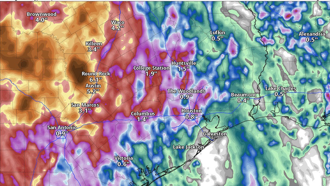
Camp Mabry, Austin’s official climate observation site, has received over 5 inches of rain since July 1, a surplus of more than 4.5 inches from the normal rainfall amount for the same period. On the city’s southeast side at Austin-Bergstrom International Airport, July rainfall so far amounts to nearly 2.5 inches with a nearly 2-inch surplus.
Radar-estimated rainfall since last week shows a few corners of Travis County have recorded in excess of 20 inches of rain, especially near Leander Hills in the northwest corner of the county.
Unfortunately, we’re not done with the potential for heavy rainfall just yet.
Downpours through Wednesday
Austin’s forecast has been plagued by a stubborn mid-level trough of low atmospheric pressure. This feature basically acts as a focal point for rising air and scattered storms.
We’ll still be under the influence of this trough Tuesday into Wednesday, though forecast modeling does suggest a weakening trend is expected. What does that mean? It means that instead of the 40-60% chance of storms we saw Monday, rain chances may drop to as low as 30%.
This daily storm risk through Wednesday will mainly be focused along and east of Interstate 35. This region has recorded between 2 and 5 inches of rain since last week, meaning more rainfall shouldn’t pose as significant a flood risk as it could if it were to fall in the western half of Travis County.
Downpours that do develop should also be moving faster than storms that developed late last week.
For these reasons, Austin’s flood risk through Wednesday is mitigated. Heavy storms that do develop could result in localized street flooding, so be mindful of that if you’re traveling across the region Tuesday or Wednesday afternoon.
Where storms aren’t providing rain-cooled relief, high temperatures each day reach into the mid-90s with humidity-driven heat index values near and above 100 degrees.
Does Austin finally dry out?
The forecast does turn drier after Wednesday.
As the trough of low pressure shifts further away Thursday into Friday, rain chances in Austin drop to essentially zero. While a stray shower can’t be ruled out for areas south of the city in the Coastal Plains, this activity should be limited in scope and intensity.
Mostly sunny skies will lead to highs through the second half of the week inching closer to the 100-degree mark. Temperatures may stay just shy of triple digits, heat index values certainly won’t. Each day will bring “feels like” temperatures to between 100 and 105 degrees.