

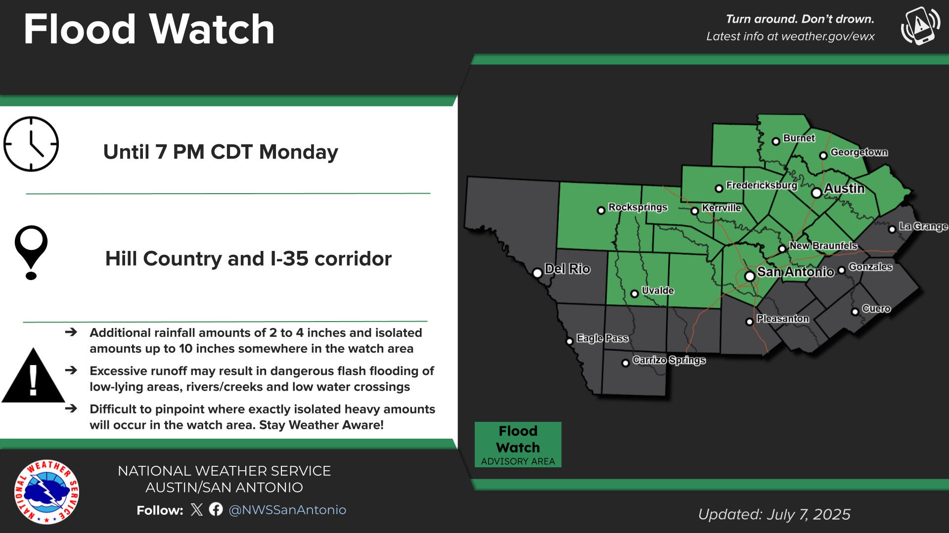
A flood watch is in effect until 7 p.m. Monday for parts of the Hill Country and the Interstate 35 corridor, including Kerrville, San Antonio and Austin, the National Weather Service said.
A threat of flash flooding remains from “slow-moving heavy rains overnight and through the day on Monday somewhere over the watch area,” the weather service warned, adding that it would be “difficult to pinpoint exact locations where isolated heavier amounts will occur.”
These Texas counties are under the flood watch: Llano, Burnet, Williamson, Edwards, Real, Kerr, Bandera, Gillespie, Kendall, Blanco, Hays, Travis, Bastrop, Lee, Uvalde, Medina, Bexar, Comal, Guadalupe and Caldwell.
Communities in the watch area include Llano, Fredericksburg, Bastrop, Uvalde, Blanco, Georgetown, Lockhart, Bandera, Austin, Rocksprings, San Antonio, Boerne, Hondo, New Braunfels, Seguin, Leakey, Kerrville, San Marcos, Giddings and Burnet.
Forecasters also noted “an uptick in coverage and intensity of scattered showers and storms is possible overnight near the I-35 corridor and eastern Hill Country, developing west through the day on Monday.”
At least 2 to 4 inches of new rainfall are possible anywhere in the flood watch area, where some isolated spots could see as much as 10 inches, the weather service said.
“Rainfall rates will be very intense in the heaviest showers and storms,” forecasters said. “Any additional heavy rainfall over hardest hit areas of the past few days will lead to rapid runoff and flash flooding.”
As of 8 a.m. Monday, a flash flood warning was already in effect for Llano County until 10:45 a.m., the weather service said.
Doppler weather radar around 7:40 a.m. spotted thunderstorms over areas where up to 2 inches of rainfall has already occurred, forecasters said. Another inch to 2 inches are possible.
Some communities affected include Llano, Gainesville, Buchanan Lake Village, Castell, Oxford, Valley Spring, Lone Grove, Baby Head, Stolz, Prairie Mountain, Enchanted Rock State Natural Area, Bluffton, Field Creek and Tow.