

If you’ve noticed the weather heating up and feeling more like summer recently, you can thank or blame a ridge of high atmospheric pressure that has pushed temperatures steadily into the upper 90s and humidity-driven heat index values into the triple digits.
The heat dome created by high pressure has been influencing the weather over the eastern third of the country, causing heat index values of 105 to 110 in cities across the Deep South like Little Rock, Memphis and New Orleans.
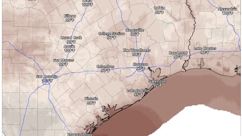
This weather feature will remain focused on Texas through Thursday and will likely push Austin’s temperatures to the century mark for the first time since mid-May. Factoring in the humidity levels, the heat index is expected to range from 102 to 104 degrees.
This level of heat could cause heat-related illnesses for Texans who are particularly sensitive to high temperatures, as well as for those without access to adequate cooling or hydration. The National Weather Service Heat Risk Map indicates a moderate heat threat across Central Texas for Thursday afternoon.
Luckily, the triple-digit heat won’t stick around long as the high pressure shifts north as expected. However, we’ll then have to turn our attention to the tropics.
An area of low pressure is expected to move westward across the warm waters of the Gulf of Mexico, along the southern edge of the high pressure ridge — it’s a setup similar to last week, when a tropical disturbance dumped heavy rainfall in Florida, Louisiana and East Texas. The National Hurricane Center has given this latest disturbance an especially low chance of tropical cyclone development in the coming days.
As the ridge of high pressure shifts north, it will allow tropical moisture to flow into Texas, bringing scattered showers and thunderstorms to Central Texas by Friday afternoon and continuing through the weekend. Currently, rain chances are highest on Saturday afternoon, with a 30-40% likelihood.
After the weekend’s rain chances, the high pressure system is expected to return to the region early next week, gradually increasing temperatures again to around 100 degrees by next Wednesday.
Fast forward to next month — yes, we are only a week away from August — and our weather will be more typical for this time of year. While heat looks to build a little more across West Texas, more wet weather is possible along the upper Texas Gulf Coast.
The return of 100-degree days
We’ve only recorded two 100-degree days so far this year at Austin’s main weather stations, Camp Mabry and Austin-Bergstrom International Airport: May 13-14. Austin's first 100-degree day of the year has occurred earlier on the calendar only two other times. The earliest date for triple-digit temperatures in Austin is May 4, when temps hit 100 degrees that day in 1984, followed by May 7, when temps hit 102 that day in 1998.
At this time last year, Camp Mabry had already recorded 14 such days, eventually tallying 32 days with triple-digit temperatures for the year. However, this pales in comparison to 2011, one of Austin's hottest years on record, which produced a staggering 90 days with temps of 100 degrees or higher.
Since 2000, the Austin area has recorded an average of 37 days of triple-digit temperatures annually, typically starting on June 23 and ending on Sept. 5. However, last year, the final 100-degree day occurred on Oct. 13, setting a record for the latest date that Austin has experienced 100-degree temps.