

After temperatures closed in on the 100-degree mark Thursday — and a “Save energy” alert was sent by Austin Energy — a dramatic weather shift is expected on Friday and through this weekend as an upper-atmosphere low pressure system and a surface low move ashore in Texas.
Although this tropical disturbance looks similar to last weekend’s tropical system in the Gulf of Mexico, which eventually traveled inland across Louisiana, this tropical low will take a different path.
The subtropical high pressure system that brought back the abundant sunshine and above-normal heat this past week will shift north a little bit. This shift should allow for a greater influx of tropical moisture, and southeast winds will help steer the rain-making low pressure system into Texas.
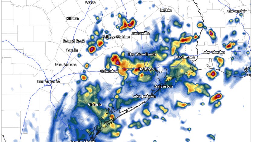
This broad area contains showers and thunderstorms but remains disorganized. Despite being over warm waters, the National Hurricane Center has given it only a small chance of development over the next few days. Nevertheless, pockets of heavy rainfall and gusty winds are expected to reach the Texas coast by Friday morning, spreading west and northwest into Central Texas by Friday evening.
Rain chances will increase quickly, rising from about 20% around lunchtime to 40-50% from Friday night through Saturday. A few scattered thunderstorms will linger into Sunday afternoon.
As with any tropical system, we can expect the rounds of showers and thunderstorms to be tied to rain bands, meaning the rains this weekend will be sporadic but you’ll want to be prepared and keep an umbrella handy.
Temperatures will respond to the increased clouds and moisture over the weekend, with highs reaching the mid-90s on Friday, then only the lower 90s on Saturday, and back into the mid-90s on Sunday.
So far, flooding is not a major concern, as rainfall amounts are expected to be around an inch to 2 inches along the coast, and about a quarter-inch to a half-inch in the Austin area. The National Weather Service’s Weather Prediction Center has placed the Houston area along and south of Interstate 10 under a level 1 of 4 risk, or at least a 5% chance, of flash flooding.
“NASA Sport Soil Moisture data shows relatively dry conditions along the coast, so the bulk of the rainfall should mostly be beneficial in nature,” the regional weather service office for Houston and Galveston said in a forecast bulletin Thursday.