

As we wind down a historic month for Central Texas weather, this past week brought its share of notable weather: Thursday marked our third day of 100-degree temperatures for the year and the first for this summer, only to be followed by a dramatic shift Friday morning as a blanket of clouds rolled in from the coast, courtesy of a tropical low pressure system pushing inland.
While the tropical low never materialized into anything close to a named storm, it will definitely put a damper on weekend beach plans along the Texas Gulf Coast. Intermittent rain, thunderstorms and gusty winds are anticipated throughout Saturday and into Sunday.
The dry and hot air mass that was responsible for pushing temperatures into the triple digits earlier this week is giving way to a moist and unstable air mass this weekend. As a result, the tropical low pressure system will bring scattered showers and isolated thunderstorms on Saturday, primarily along and east of the Interstate 35 corridor. Austin will see rain chances near 40%, decreasing to just 20% farther west in the Hill Country.
This is great news if you were hoping to head out to the Highland Lakes for a fun afternoon on the water. Lake Travis is officially open as of Thursday, according to a social media post from Travis County officials.
"Travis County Judge Andy Brown has updated the disaster declaration related to the July 5th flood to allow recreational use of ALL of Lake Travis, but boaters and swimmers are still asked to be cautious," the post stated.
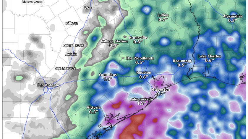
Luckily, rain won’t ruin the entire day, at least not with rainfall totals ranging between 0.1 inch and a quarter-inch, with isolated areas potentially receiving up to a half-inch of rain.
Higher rainfall totals will be concentrated in Southeast Texas, where the National Weather Service’s Weather Prediction Center has identified the potential for flooding rainfall in its daily outlook.
The Weather Prediction Center outlook specializes in alerting the public when there is a risk of flash flooding in specific areas. It indicates the likelihood of encountering flash flooding within 25 miles of your location. Currently, Southeast Texas is under a level 1 out of 4 risk, or at least a 5% chance, of flash flooding. Any flooding that occurs is expected to be localized, particularly in places prone to rapid runoff and poor drainage during heavy rainfall.
Temperatures this weekend will remain cooler and below average, peaking only in the low 90s on Saturday and the lower to mid-90s on Sunday, thanks to increased cloudiness and rain chances.
By next week, sunshine, heat, and high pressure will return, bringing drier conditions and pushing temperatures to near 100 degrees by Tuesday and Wednesday. Looking ahead to late next week, yet another low pressure system from the Gulf of Mexico is expected to develop near the Texas coastline, increasing rain chances as we move into the first week of August.